|
1. Enhanced Shortest Path Search
|
|
Significant improvements have been made to the shortest path search in SC Modeler 4.1, enabling the creation of responsive animated simulations, dynamic routing visualization, and performance analysis of large-scale multi-layer satellite networks.
|
|
The table below displays the frame refresh time for animated simulations of dynamic routing between two ground stations situated at opposite points on Earth, one at 45°N and the other at 45°S. For constellations containing thousands of satellites, this time is primarily determined by satellite movement propagation and the shortest path search.
|
Frame Refresh Time - Satellite Network
| Number of Satellites |
Orbital Structure |
ISL per Satellite |
Orbit Propagator |
Frame Refresh Time (sec) |
| 5,000 |
Kinematically Regular ("Walker delta"), 100 orbital planes |
4 |
Two-Body Keplerian with J2 Perturbations |
0.08 |
| 10,000 |
Kinematically Regular ("Walker delta"), 100 orbital planes |
4 |
Two-Body Keplerian with J2 Perturbations |
0.24 |
| 4,868 |
Starlink, TLE-defined, 4,868 orbital planes |
Unrestricted, 500+ potential ISL per satellite (this network topology does not reflect the actual one and was chosen for application performance validation only) |
SGP4/SDP4 |
0.14 |
|
Notes:
- PC Configuration: Laptop with an 11th generation Intel Core i7 processor, 2.80GHz, 16 GB RAM, integrated video card.
- Routing policy: The total length of the path from the source node to the destination node.
- Orbit altitude for the first two constellations: 485 km, inclination - 53.75°.
- Uplink/Downlink field-of-view: Simple conic with a minimum ground elevation angle of 25°. Using instead a custom sensor defined by the Azimuth-Elevation mask resulted in a 5 to 15% increase in the Frame Refresh Time.
- The Network Topology Tools were used to define the network topology for kinematically regular constellations.
- The Starlink TLE dataset contained currently active and decayed satellites. Decayed satellites have been excluded from the path search.
- The frame refresh rate was nearly identical for all three constellation visualization modes - 2D, 3D, and 3D OpenGL.
- The Total Path Delay task was turned on and running during simulations, displaying the results in a dedicated area of the application window.
|
|
2. Ground-Based Relay Stations
|
|
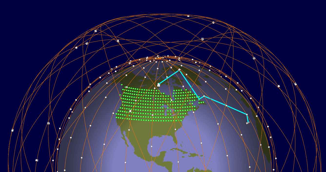
SC Modeler 4.1 introduces the possibility to explore the use of ground-based relay stations that can forward data between satellites. This capability can either complement or replace intersatellite links within a satellite network.
|
|
The application allows for the addition of tens of thousands of ground relay stations to a satellite network.
|
Frame Refresh Time - Satellite Network with Ground Relays
| Number of Relays |
Number of Satellites |
Orbital Structure |
ISL per Satellite |
Orbit Propagator |
Frame Refresh Time (sec) |
| 5,150 |
5,000 |
Kinematically Regular ("Walker delta"), 100 orbital planes |
4 |
Two-Body Keplerian with J2 Perturbations |
0.11 |
| 5,150 |
4,868 |
Starlink, TLE-defined, 4,868 orbital planes |
- |
SGP4/SDP4 |
0.25 |
| 42,000 |
4,868 |
Starlink, TLE-defined, 4,868 orbital planes |
- |
SGP4/SDP4 |
0.34 |
|
Notes:
- Ground relays were evenly distributed within North America, covering latitudes between 25°N and 60°N. Two ground stations (user terminals) were placed near the northwest and southeast corners of the area.
- Only "representative" ground relays (less than 10% of the total) have been displayed. All satellites and satellite orbits (in 3D and 3D OpenGL modes) have been visualized.
- The program conducted the shortest path search at each time step during simulation. Switching to a delayed search mode, which postpones path refresh until either the route becomes invalid or for a specified period of time, significantly decreases the average Frame Refresh Time.
|
|
3. Routing Settings Tool
|
|
The Routing Settings tool now offers the ability to define a balanced hierarchical search and choose between the Dijkstra algorithm, Breadth-First Search, and A* Search, depending on the selected routing policy.
|
|
4. Network Topology Tools Usability Improvements
|
|
5. TLE Update Utility
|
|
SC Modeler 4.1 includes the TLE Update Utility, which provides automatic updates of TLE database records.
|
|
Note: A Space Track (space-track.org) account is required to use this tool.
|
|
6. Route Explorer
|
|
7. Many other feature improvements and bug fixes
|
|